
Moab Area Biking Trails
The Moab Slickrock Bike Trail is well known as one of the nation's superior mountain bike trails, but local riders know that it is but one of many great rides in the Canyon Country. Here we briefly describe the Slickrock Trail and three other day rides near Moab.
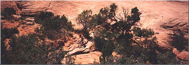
1 - SLICKROCK BIKE TRAIL
Beginning Point: On Sand Flats Road, 2.3 miles from the intersection of the Sand Flats Road and Millcreek Drive in Moab.Length: 9.6 miles (main loop); 2.2 miles (practice loop) [ Map | Photo Gallery ]
Type of Ride: slickrock; loop ride
Area Attractions: The Slickrock Trail possesses a terrific combination of challenging riding and scenery. The practice loop offers an introduction to riding on slickrock.
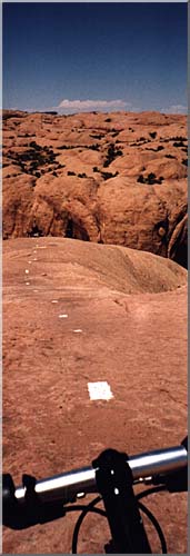
Route Description: The trail is marked by white dashes painted on the slickrock. Intersections, points of interest and caution zones are indicated with yellow paint.
The Slickrock Trail was originally designed for motorcycle use. The trail is open to both motor and pedal bikes.
The Slickrock Trail is the most difficult trail described in this brochure. It is both technically demanding and strenuous. Novice riders should test their riding skill and stamina on the practice loop prior to attempting the main route. Be certain that your brakes are in good working condition.
2 - MONITOR & MERRIMAC TRAIL
Beginning Point: Drive north on U.S. 191 for approximately 15 miles then turn left onto a dirt road just north of highway marker 141, cross the tracks and follow the dirt road for 0.6 mile to an intersection which is the starting and ending point of this loop ride.Length: 13.2 miles
Type of Ride: 4-wheel drive trail, wash bottom, and slickrock; loop ride.
Area Attractions: Close view of the Monitor and Merrimac buttes, Determination Towers, and the Mill Canyon Dinosaur Trail
Route Description: From the parking area, take the right fork. The first part of the ride is through open desert. The road goes past a large power line and crosses a large wash 2.2 miles from the parking area. The route goes left up the wash into the Tusher Canyon drainage. (Do not follow the road which goes up a short hill). This wash is ridable, as it almost always has a small flow of water near its surface for much of the route. After 0.6 mile, a road climbs out of the wash to the right. Continue up the wash for another 1.2 miles. From this point, follow a left branch of the wash up through a gap in the large wall dividing the Tusher and Mill canyon drainages. Determination Towers are visible through the gap. At the gap, you will find a gate. Leave it open or closed as you find it. Follow the 4-wheel drive road towards the towers.
Just past the towers, ride up unto the slickrock and head toward the towers. Cross the large flat slickrock area on the eastern side of the towers and follow another 4-wheel drive trail that heads up toward Monitor and Merrimac buttes. It is 1.2 miles from the towers to the base of Merrimac Butte. There are several sections of sand along this portion of the route.
At an intersection near Merrimac Butte, go left for 0.7 mile to a five-way intersection. Take the 45 degree right fork that goes between Monitor and Merrimac buttes. Most of this trail is over slickrock. You will have a good view of the Seven Mile Canyon area, south of the buttes, from a large slickrock "platform" located between the buttes. To continue the ride, retrace your route back to the five-way intersection and take the road that heads directly down into Mill Canyon. Go past the Determination Towers and enter Mill Canyon. At the lower end of the canyon pass through a gate, leaving it open or closed as you find it.
About 0.2 mile from the gate, a spur road will take you to the start of the Mill Canyon Dinosaur Trail. Many dinosaur fossils may be seen along this nature trail. Please leave your bike at the trailhead. From the dinosaur trail, follow the road north to your vehicle.
3 - GEMINI BRIDGES TRAIL
Beginning Point: On Highway 313 at a point 0.9 mile west of the Mineral Bottom turnoff (12.6 miles west of the Utah 313/US191 junction).Length: 13.5 miles
Type of Ride: dirt road; shuttle required
Area Attractions: Gemini Bridges, a pair of natural rock spans; spectacular views of Behind the Rocks; and colorful rock formations.
Route Description: The Gemini Bridges Trail is well known to local riders for its scenery and long de- scents. Starting from Utah 313, the trail, except for the climb out of Little Canyon, is nearly all downhill back to Highway 191.
The first section of the trail is a rapid descent for 3.8 miles along a graded road through pinyon-juniper woodland. Just after the road enters a huge open flat, turn right off the main road and go past an abandoned drill site (note the large metal post). Ride under a power line and descend into a wooded area where, after 0.9 mile, you will come to the intersection with the Four Arches Trail.
From the intersection of the Four Arches Trail and the Gemini Bridges Trail, continue to parallel the Bull Canyon system (on your right) until just before the end of the large open area. At this point, which is 0.6 mile from the Four Arches intersection, an- other trail crosses your route; go right at this inter- section and then up over a low sandy hill and descend to the Gemini Bridges. The Gemini Bridges are located at the end of this spur which is about 0.2 mile long.
Near the head of the canyon, the road leaves the canyon bottom and climbs a fairly steep grade. The road then contours high above Highway 191. At this point, from your narrow perch on the road, you will have a spectacular view over Arches National Park. The road then quickly descend s to the railroad tracks and Highway 191.
If you have left a vehicle here, then it is time to begin your shuttle. To avoid highway traffic in Moab Canyon, ride south on U.S. 191 for about 200 yards from the lower Gemini Bridges trailhead, then turn left onto a dirt road. Cross the yellow cattleguard and then follow the road to the right for a scenic ride‚ through Moab Canyon that ends about 1/2 mile North of the Arches National Park entrance road. Some riders prefer to ride back to Moab.
4 - HURRAH PASS TRAIL
Beginning Point: The junction of Highway 19l and Kane Creek Boulevard in Moab.Length: 33 miles round trip from Moab
Type of Ride: Paved road and graded dirt road; out and back type ride.
Area Attractions: Views of the Colorado River, petroglyphs, scenic canyon.
Route Description: From the junction of Highway 191 and Kane Creek Boulevard in Moab, follow Kane Creek Boulevard west to its "Y" with Fifth West. Go left. In about 0.5 mile, the road reaches the Colorado River. The pavement ends after 2 miles at the mouth of Kane Creek Canyon. The road initially parallels the stream, then climbs high above it. Stop at the turnout before the road heads down the switch- backs for a view of the canyon and its surrounding ocean of rock. Try to pick out the route of Kane Creek as it meanders toward the Colorado River. From the pass, it is a quick ride down through a pair of steep switchbacks to Kane Creek. Below the switchbacks is a grove of shady cottonwoods -- and pouring from the wall along the left side of the road a spring. In another mile, the road passes the mouth of Hunter Canyon. Beyond Hunter Canyon, Kane Creek Can- yon opens up into a huge amphitheater. The high point ahead is Anticline Overlook. Hurrah Pass is located below and to the right of the point.
Follow the road over a low hill by some colorful rock formations to where it crosses Kane Creek (may be dry). Ride straight ahead to a "Y" junction. The Kane Creek Canyon 4-wheel drive trail goes left. Take the right fork to Hurrah Pass. From here, it is nearly all uphill. The road follows one of those improbable routes found only in Canyon Country as it snakes its way up a series of narrow Moenkopi Formation ledges. On the way to the pass, you will be rewarded with spectacular red-rock country views. This ride may be shortened by starting at a point farther along the route such as the entrance to Kane Creek Canyon.
CANYON COUNTRY MINIMUM IMPACT PRACTICES
1. Tread lightly when traveling and leave no trace of your camping. Drive and ride only on roads and trails where such travel is allowed: hike only on established trails, on rock, or in washes. Camp at designated sites or, where allowed, at previously-used sites. Avoid placing tents on top of vegetation and use a camp stove instead of making a campfire. Unless signs indicate otherwise, leave gates open or closed as you find them.2. Help keep Canyon Country clean. Pack out your trash and recycle it, clean up after less thoughtful visitors, and dispose of human waste properly.
3. Protect and conserve scarce desert water sources. Camp at least 300 feet from isolated water sources to allow for wildlife access. Where possible, carry your own drinking water. Leave potholes undisturbed and wash well away from pools and springs.
4. Allow space for wildlife. When encountering wildlife, maintain your distance and remain quiet. Teach children not to chase or pick up animals. Keep pets under control.
5. Leave historic sites, Native American rock art, ruins and artifacts untouched for the future. Admire rock art from a distance and never touch it. Stay out of ruins, leave artifacts in place, and report violations.
Essential Equipment checklist
- helmet(head injuries can cost $500,000!)
- two water bottles plus a large reserve bottle
- high energy food
- sun visor, sunscreen, and sunglasses
- route map
- tire pump, tire irons, and patch kit
- bike repair tools
- first-aid kit
- riding gloves and sturdy shoes
- riding shorts, T-shirt, and wind shirt
- riding tights or long underwear
- sweater and gloves
- earband
- rain gear
If you have an accident in a remote area, it may take medical he!p hours to arrive. Travel with a group so that someone can be sent to obtain help and another rider can administer first aid. On a hot day, you will want to have more water than your frame-mounted bottles hold. Carry a large refill bottle on your rack. If your bike breaks down, it can be a long push back to town. Carry appropriate tools and know how to repair your bike.
Minimum Impact Biking Practices
Each year, individuals take hundreds of thousands of mountain bike rides in the Moab area. You can help protect this fragile land by adhering to the following minimum impact biking practices, and the Canyon Country Minimum Impact Practices.- Ride only on open roads and trails. Riding cross-country, taking short cuts, and play riding around campsites
damages plants and soils.
Don't be a trail pioneer by leaving a poorly chosen
path for others to follow. Help land managers keep
areas open to biking by staying on established routes.
- learn to recognize and preserve cryptobiotic
soil crusts. This delicate, often black, crusty-looking, complex of
soil and slowly growing algae, mosses, bacteria, and
lichens retains water, reduces erosion, and provides
a stable base from which higher plants can flourish.
It takes many years for cryptobiotic soil crust to
recover from the ruts created by one bike. If you
don't know what it looks like, ask someone to point
it out!
- Avoid skidding your tires. Locking your wheels needlessly damages trails and
leaves ugly tire marks on slickrock. Stay in control by
"feathering" your brakes.
- Ride rocky, slickrock, and sandy areas when it's
wet. Soils with high clay content, e.g. the first several miles
of the Monitor and Merrimac Trail, turn to slippery,
chain-clogging mud when wet. Riding through these
areas under wet conditions leaves deep ruts that accelerate trail erosion.
- Refrain from riding through and camping in riparian areas. Riparian areas, the communities of water-loving
plants along streams, are precious to wildlife. Wildlife concentrate in
these areas and can be displaced by
recreation use.
- Protect water sources. Washing mud off bikes and bathing can introduce lubrication, soaps, and oils from sunscreen into water sources critical for the survival of small animals.
ADDITIONAL INFORMATION
For more information about these trails, additional mountain bike opportunities, and minimum impact riding, visit the Moab Information Center located at Center and Main in downtown Moab.
Thanks to Grand County Travel Council in cooperation with The Bureau of Land Management

Mention this web page when you call!

All contents of this page - Copyright 1997, 1998 Moab Internet.
We provide updated http://www.leather4sure.com/suede-jackets.html with 100% pass guarantee along with http://www.leather4sure.com/item/905.html.